Bryce Canyon---Escalante---Coyote Gulch---Hole in the Wall
I have not done an "adventure" write up in quite some time. Since my last post: I ran the Zion Traverse, skied a ton, climbed all over the state, climbed some ice, and DNF'd at the Buffalo100 after 80 miles. Not really blog worthy stuff. But I had a blast this week-end and FINALLY made it down to explore (a tiny tiny piece of) the Escalante. Kind of embarrassing it has taken this long.
I don't normally take tons and tons of pictures, but this excursion was amply chill enough to overload the SD cards so I will just narrate by pic.
 |
| We made it down to our "secret" camp spot near Bryce at 12 am with mucho snow and sub 30 degrees F. With extra pads and blankets and we slept warm and snug though I always get more sleep that Izzy... because I don't have one (or more) kids in my bag. |
 |
| Way better than ice cold cream cheese and flat bagels. GO UTES |
 |
| Our plan was to go straight to the our trail head down the Hole-in-the-Wall Road in Escalante but with all the snow we stopped by Bryce to kill some time and see how the weather played out. |
 |
| Izzy sportin her new bday coat and J wondering why his parents subject him to these freezing outings. |
 |
| mmm good memories |
 |
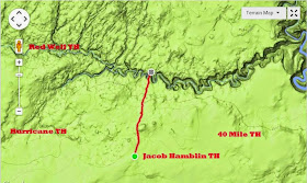
| Most folks hike Coyote Gulch via Hurricane, Red Well, or 40 mile (Crack in the Wall) Trail Heads. We chose the most direct path almost straight North 2.1 miles. Awesome cross country navigation and scenery to a 100 yd 4th class down climb. We shuttled the packs and took it slow. Easy peasy even with the little ones. But I would not recommend it to non climber folk to attempt sans ropes and know how. The down climb drops you straight out at the best spring in the canyon and one of the most impressive arches in the World |
 |
| Easy hike for one of the team |
 |
| Not so easy for all |
 |
| "Leave nothing but foot prints take nothing but epic desert pics" |
 |
| Calico waves |
 |
| Petrified Sand Dunes |
 |
| "keep heading North and we are bound to run into a hole" |
 |
| My pants are too big. My dad used webbing for a belt. And I'M TIRED |
 |
| ..then out of no where a huge canyon and the top of an amazing arch |
 |
| quick 100 yrd down climb. |
 |
| Amanda liked this eddy more that the arch (seen middle) |
 |
| "I like camping under mondo huge arches" |
 |
| Best camp spot ever |
 |
| The next day I got up at 6 am and ran with a small water bottle 6.3 miles down to the Escalante and Stevens Arch then climbed up and out and back on the rim. 11 miles 3 hrs. It was so so dang pretty I almost felt guilty running |
 |
| Some arch (4 total) |
1 of 4 waterfalls
 |
| Confluence |
 |
| Super Cool Spot where the Gulch meets the Escalante |
 |
| I honestly made it 15 minutes up the sandy exit trail before I turned around and saw what is now one of my favorite arches I have ever seen. Stevens Arch (even if it is spelled wrong) |
 |
| Rim Shot |
 |
| GoPro rim shot |
 |
| route beta note: this is the only fence when you cross it you are nearing the decent back down to J Hamlin Arch |
 |
| Moqui Marbles |
 |
| Super hiker made it all the way back to the car on her own 2 feet |
 |
| Geek Stats: My back weighed 38 lbs with Anna on my shoulders 68 lbs total. Amanda carried 24 lbs with a 12 lb baby. 36 total. |
 |
| We decided to drive an extra 45 miles of horrible dirt road to the actual hole in the wall. 250 pioneer carts made in down the slot to the pre Lake Powell valley below. Pretty amazing sight to see after the long dirt road. |
 |
| Wow. only a quick 40 minute jaunt down to the Lake to swim around. Then 57 more miles of hellish wash board dirt road. |


